Jasper Alberta
Jasper Alberta Natural Wonder
Jasper Alberta's Historical Timeline
Jasper National Park
History
Canada's Largest National Park
Jasper Alberta's Climate
Warmer and drier climates that followed their last major advance, the retreating glaciers left exposed a barren and raw landscape in Jasper National Park, Alberta. Soon plants and animals began to take advantage of these newly-exposed expanses, infiltrating the Albertan mountain valleys from ice-free areas. Some of these organisms invaded from regions to the south that had remained unglaciated. Other organisms arrived from their unglaciated mountain peak refuges, islands of rock that the glaciers had failed to cover.
Jasper Alberta's climatic condition adjacent to melting glaciers were far from ideal for survival, but the constant glacial winds kept nearby valley bottoms mostly snow-free and the melting ice provided an abundance of water. Grasses and other hardy, cold-resistant species of vegetation soon took root in glacial silt and colonized the open spaces. Once this food source was established, large mammals such as bison, elk, deer, bighorn sheep and mountain goats gained a foothold in the Jasper area.
As time passed, Jasper's climate continued to moderate. Glaciers dwindled and disappeared from all but the higher areas near the continental divide. As the annual cycle of growth and decay in the grasslands broke down the rock rubble and built up nutrient-rich soils, trees took root and spread through the valleys. During the warmest periods, between about 7000 and 3500 years ago, it is likely that grasslands and drier forests dominated Jasper Alberta, at least at lower altitudes. This combination of climate and habitat encouraged the growth of bison, elk and mountain-sheep herds.
More recently, during the Little Ice Age (1200 to 1850 A.D.), the onset of cooler temperatures and higher snowfall initiated a minor advance of the glaciers from their Albertan mountain strongholds. These colder conditions pushed Jasper's treelines lower and permitted cold-tolerant spruce and fir forests to dominate the mountain slopes, much as they do today. Caribou, moose and bison, all species adapted to travel in deeper snow, frequented much of the area, while elk and deer were confined to the grasslands still covering the bottom lands of the lower Athabasca Valley and the slopes of the drier front ranges.
During the past 150 years the climate has continued to fluctuate. Vegetation patterns have responded to its changes. Occasional severe winters, drought and periodic fire have played their part in shaping the ecology of the mountain regions. Numbers of animals, not to mention numbers of humans, have all been affected by the prevailing climate.
Although the Pacific Ocean lies several mountain ranges to the west, ocean winds influence much of Jasper's weather and contribute to the forces of change in the mountains. The winds rush up and over the main ranges. Moisture-laden clouds dump metres of snow and water in highlands such as the Columbia Icefield. Drier winds flow northeast down the Athabasca Valley, lifting sand and silt and sweeping slopes bare in their wake.
When the dominant west wind falters, Arctic fronts sweep in from the north and east and the temperature plummets. The park's northerly location and distance from the ocean make the climate of Jasper National Park 'continental', with long, cold winters and short, warm summers.
Geology of Jasper Alberta
Jasper National Park is an area of dramatic mountain peaks and expansive valleys. Many of the mountains rise to elevations above 3000 metres. Mt. Columbia, the highest peak in Alberta, is 3782 metres. The lowest point in the park, 985 metres above sea level, lies near the park's east gate.
The mountains in Jasper National Park form ranges running parallel to one another in a northwest to southeast alignment. The westernmost range in this series is the highest. It also forms the continental divide, separating streams that flow east and north to the Arctic Ocean or Hudson Bay from those which drain westward to the Pacific Ocean.
In places, gaps or passes form breaks in the steep-walled ranges and allow travel from one watershed to another. Rivers have also eroded passages through this otherwise rugged and precipitous land.
To remember Rockies geology, take it range by range. The main ranges are the highest ranges (they include Mt. Robson and the group of mammoth peaks surrounding the Columbia Icefield). The main ranges form the continental divide, which splits North America into eastern and western slopes. In Jasper National Park, the main ranges are largely coarse sandstone, limestone, shale, and a somewhat metamorphic rock called quartzite, in particular, 'Gog' quartzite.
East of the main ranges are the front ranges of the Rockies. The sea allowed for the profusion of a great many plants and animals here, probably because of its shallowness. The organic material that resulted contributed lime mud, which thickened and hardened into massive amounts of limestone. The front ranges are pale grey (from the lime) and distinct from the reddish/brownish main ranges. Typical front-range peaks in Jasper are the Colin Range and Roche Miette. Farther east, out of the park, we get to the foothills, those gentle mounds that appear just before the flatness of the plains.
You will not see the western ranges in Jasper National Park. They are located south of here, in Kootenay and Yoho national parks.
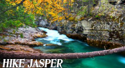
The Athabasca River and its tributaries drain more than four-fifths of the park. From the toe of the Columbia Glacier the Athabasca flows north and east through the park for nearly 150 kilometres. Ten other moderately-sized rivers and countless smaller creeks augment its volume over this distance. The Athabasca is one of the more significant rivers which flow from the mountain barrier toward the Arctic Ocean. The portion of the Athabasca which lies within Jasper National Park has been designated as a Canadian Heritage River.
Part of the north end of Jasper National Park lies in a different drainage basin than that of the Athabasca. The Smoky River, which originates in the extreme northwest corner of the park, courses northward to the Peace River in northern Alberta.
Water from the most southeasterly corner of the park is discharged via the Southesk and Brazeau rivers, which exit from the mountains and join the North Saskatchewan River.
These watercourses collect the runoff from an area of over 10,000 square kilometres. Peak flow begins in late June, when snowmelt and rainfall combine to fill the river channels to capacity. Melting glaciers keep the water levels high through July. In midsummer, these rivers contribute significantly to the water supply required for municipal and agricultural needs farther downstream.